Quickly convert hours to months and vice versa at Examples.com. Input your values for instant and precise calculations.
hr to mo
Formula: Time in months(mo) = Time in hours(hr) ∕ 730.485
Hours :
Months :
| hours | months |
|---|---|
| 1 | 0.001368953503494254 |
mo to hr
Formula: Time in hours(hr) = Time in months(mo) x 730.485
Months :
Hours :
| months | hours |
|---|---|
| 1 | 730.485 |
Time Converters to Hour (hr)
| Nanosecond to Hour | Microsecond to Hour | Millisecond to Hour |
| Second to Hour | Minute to Hour | Day to Hour |
| Week to Hour | Month to Hour | Calendar Year to Hour |
| Decade to Hour | Century to Hour |
Time Converters to Month (mo)
| Nanosecond to Month | Microsecond to Month | Millisecond to Month |
| Second to Month | Minute to Month | Hour to Month |
| Day to Month | Week to Month | Calendar Year to Month |
| Decade to Month | Century to Month |
Conversion Factors:
- Hours to Months: 1 month = 730 hours (assuming an average month of 30.42 days)
- Months to Hours: 1 hour = 1/730 months
How to Convert Hours to Months:
To convert hours to months, divide the number of hours by 730.
Months=Hours/730
Example: Convert 2000 hours to months.
Months=2000/730=2.7397 months
How to Convert Months to Hours:
To convert months to hours, multiply the number of months by 730.
Hours=Months×730
Example: Convert 3 months to hours.
Hours=3×730=2190 hours
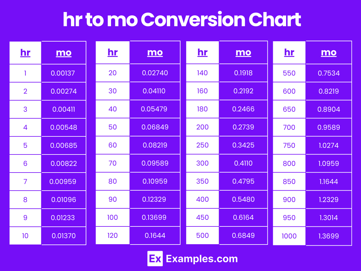
Hours to Months Conversion Table
| Hours (hr) | Months (mo) |
|---|---|
| 1 hr | 0.00137 mo |
| 2 hr | 0.00274 mo |
| 3 hr | 0.00411 mo |
| 4 hr | 0.00548 mo |
| 5 hr | 0.00685 mo |
| 6 hr | 0.00822 mo |
| 7 hr | 0.00959 mo |
| 8 hr | 0.01096 mo |
| 9 hr | 0.01233 mo |
| 10 hr | 0.01370 mo |
| 20 hr | 0.02740 mo |
| 30 hr | 0.04110 mo |
| 40 hr | 0.05479 mo |
| 50 hr | 0.06849 mo |
| 60 hr | 0.08219 mo |
| 70 hr | 0.09589 mo |
| 80 hr | 0.10959 mo |
| 90 hr | 0.12329 mo |
| 100 hr | 0.13699 mo |
hr to mo Conversion Chart
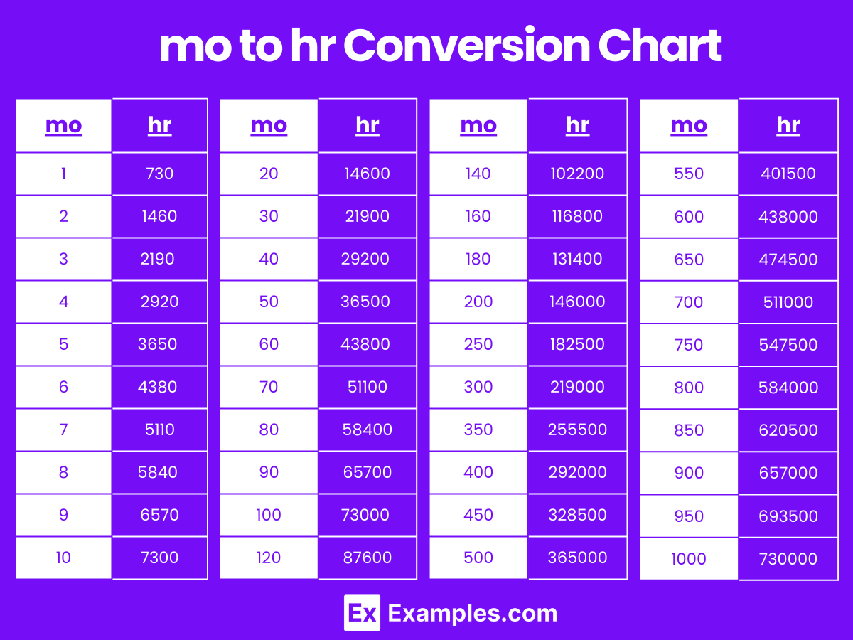
Months to Hours Conversion Table
| Months (mo) | Hours (hr) |
|---|---|
| 1 mo | 730 hr |
| 2 mo | 1460 hr |
| 3 mo | 2190 hr |
| 4 mo | 2920 hr |
| 5 mo | 3650 hr |
| 6 mo | 4380 hr |
| 7 mo | 5110 hr |
| 8 mo | 5840 hr |
| 9 mo | 6570 hr |
| 10 mo | 7300 hr |
| 20 mo | 14600 hr |
| 30 mo | 21900 hr |
| 40 mo | 29200 hr |
| 50 mo | 36500 hr |
| 60 mo | 43800 hr |
| 70 mo | 51100 hr |
| 80 mo | 58400 hr |
| 90 mo | 65700 hr |
| 100 mo | 73000 hr |
mo to hr Conversion Chart
Difference Between Hours to Months
| Aspect | Hours (hr) | Months (mo) |
|---|---|---|
| Definition | A unit of time equal to 60 minutes or 3,600 seconds. | A unit of time roughly equal to 30.42 days. |
| Symbol | hr | mo |
| Usage | Used to measure short to medium durations, such as work shifts and meetings. | Used to measure longer durations, such as project timelines and gestation periods. |
| Conversion Factor | 1 hour ≈ 0.00137 months | 1 month = 730 hours |
| Measurement Tools | Measured using clocks and timers. | Measured using calendars and planners. |
| Smaller Units | Minutes, seconds | Days, hours |
| Larger Units | Days, weeks | Years, decades |
| Practical Examples | Scheduling appointments, tracking work hours. | Planning projects, tracking pregnancy, budgeting time for long-term goals. |
| Representation | Commonly visualized on clocks and watches. | Commonly represented in calendars and schedules. |
1. Solved Examples on Converting Hours to Months
Example 1:
Problem: Convert 1000 hours to months.
Solution: Since 1 month = 730 hours
Months=1000 hours/730 hours/month-1.3699 months
Example 2:
Problem: Convert 500 hours to months.
Solution: Months=500 hours/730 hours/month≈0.6849 months
Example 3:
Problem: Convert 200 hours to months.
Solution: Months=200 hours/730 hours/month≈0.27397 months
Example 4:
Problem: Convert 1500 hours to months.
Solution: Months=1500 hours/730 hours/month≈2.0548 months
Example 5:
Problem: Convert 300 hours to months.
Solution: Months=300 hours/730 hours/month≈0.41096 months
2. Solved Examples on Converting Months to Hours
Example 1:
Problem: Convert 2 months to hours.
Solution: Since 1 month = 730 hours,
Hours=2 months×730 hours/month=1460 hours
Example 2:
Problem: Convert 0.5 months to hours.
Solution: Hours=0.5 months×730 hours/month=365 hours
Example 3:
Problem: Convert 3 months to hours.
Solution: Hours=3 months×730 hours/month=2190 hours
Example 4:
Problem: Convert 1.5 months to hours.
Solution: Hours=1.5 months×730 hours/month=1095 hours
Example 5:
Problem: Convert 4 months to hours.
Solution: Hours=4 months×730 hours/month=2920 hours
Is the conversion factor the same for all months?
No, the conversion factor of 730 hours is an average. Individual months vary slightly (e.g., February has fewer days, while July and August have more).
How precise do I need to be when converting hours to months?
The required level of precision depends on your needs. For general purposes, the average of 730 hours per month is usually sufficient. For more precise calculations, consider the exact number of days in the specific months.
What are some practical applications of converting hours to months?
Applications include project planning, tracking long-term activities, and understanding durations in a more manageable time frame, such as months instead of hours.
Are there common errors when converting hours to months?
A common error is forgetting to divide by 730 or using an incorrect conversion factor. Double-checking calculations is important for accuracy.
What tools can I use to convert hours to months?
You can use online conversion tools, calculators, spreadsheets (like Excel), or perform the calculation manually using the conversion factor.
Can I convert a fractional number of hours to months?
Yes, you can convert any number of hours to months by dividing by 730, regardless of whether the number is an integer or a fraction.