
How Geographers Collect and Use Data

Geographers collect and use data to understand spatial patterns and human-environment interactions. They gather data through various methods such as field observations, remote sensing, GIS (Geographic Information Systems), GPS, and surveys. This data helps geographers analyze spatial relationships, study demographic trends, and create predictive models for future changes. By interpreting data visually through maps, geographers can assist in decision-making for urban planning, environmental management, and policy creation. Understanding how geographers collect and use data is essential for examining global patterns and addressing complex geographic issues.
Free AP Human Geography Practice Test
Learning Objectives
For the topic "How Geographers Collect and Use Data" in AP Human Geography, you should focus on understanding methods like field observations, remote sensing, GIS, and GPS for collecting data. Learn how geographers analyze spatial patterns, use big data, and interpret census surveys. You should also grasp how this data informs decision-making, urban planning, and environmental management. Additionally, study how geographic data is used to predict trends and understand relationships between human and physical processes across various spatial scales.
How Geographers Collect Data
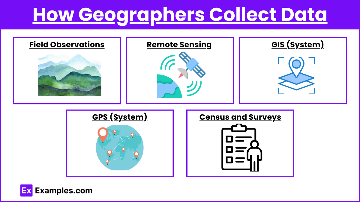
Field Observations: Geographers gather primary data by directly observing the physical and human landscapes. This includes interviews, surveys, and taking measurements in specific locations. Fieldwork helps geographers understand local environmental or cultural conditions.
Remote Sensing: Using satellite imagery and aerial photography, geographers can gather information about large areas. Remote sensing helps track land use, urbanization, environmental changes, and weather patterns over time.
Geographic Information Systems (GIS): GIS involves collecting, storing, and analyzing spatial data through layered maps. It integrates data from various sources (such as satellite images, surveys, and census data) to visualize spatial patterns and relationships, making it a powerful tool for decision-making in urban planning, environmental management, and more.
Global Positioning System (GPS): Geographers use GPS to collect precise location data. This technology helps in mapping and tracking movement patterns, such as traffic flow, migratory routes, or even the spread of diseases.
Census and Surveys: Governments and organizations collect population data through censuses and surveys. Geographers analyze this demographic data to study trends such as population density, migration patterns, and urbanization.
How Geographers Use Data
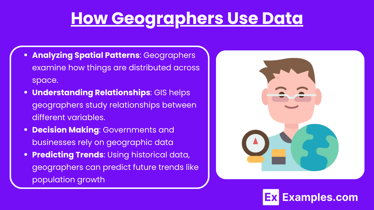
Analyzing Spatial Patterns: Geographers examine how things are distributed across space. They use data to analyze patterns such as the distribution of resources, population, or economic activities. This helps in understanding the relationship between places and how they influence each other.
Understanding Relationships: GIS helps geographers study relationships between different variables. For example, it can show the connection between income levels and housing locations, or between industrial development and environmental degradation.
Decision Making: Governments and businesses rely on geographic data to make decisions regarding resource allocation, urban development, transportation planning, and disaster management. Geographers present data visually through maps, graphs, and charts to aid in such decision-making.
Predicting Trends: Using historical data, geographers can predict future trends like population growth, urban expansion, or climate change impacts. These predictions help in planning for sustainable development.
Examples
Example 1: Field Observations
Geographers collect data through direct fieldwork, which includes making observations, conducting surveys, and interviewing people in specific locations. For instance, a geographer studying rural to urban migration may interview individuals in both rural and urban settings to understand the reasons behind migration patterns. This method provides firsthand, qualitative data that reflects local conditions and cultural practices.
Example 2: Remote Sensing
Through the use of satellite imagery and aerial photography, geographers gather data about Earth’s surface. For example, remote sensing allows geographers to monitor deforestation in the Amazon rainforest by capturing images over time, which show changes in forest cover. This data helps scientists and policymakers track environmental degradation and devise conservation strategies.
Example 3: Geographic Information Systems (GIS)
GIS integrates various types of data, including spatial and non-spatial information, to create layered maps that reveal patterns and relationships. For example, urban planners use GIS to study how transportation networks affect access to healthcare facilities in cities. By overlaying data on population density, road networks, and hospital locations, GIS helps identify areas that are underserved.
Example 4: Census Data
Governments conduct national censuses to collect demographic data, such as population size, age distribution, and employment levels. Geographers use this data to analyze population trends. For instance, census data can reveal population shifts from urban to suburban areas, helping geographers understand patterns of urban sprawl and their socioeconomic implications.
Example 5: GPS Tracking
The Global Positioning System (GPS) provides accurate location data, which geographers use to study movement patterns. For example, geographers can track migration routes of wildlife species using GPS collars, or they can analyze human movement patterns in a city to optimize public transportation systems. This precise data aids in understanding how physical and human geographies intersect.
Multiple Choice Questions
Question 1
Which of the following best describes the role of Geographic Information Systems (GIS) in geographic data analysis?
A) Collecting data through satellite imagery to observe environmental changes
B) Organizing and analyzing spatial data through layered maps and multiple data sources
C) Using surveys to collect demographic data on population movements
D) Recording precise location data using GPS technology
Answer: B) Organizing and analyzing spatial data through layered maps and multiple data sources
Explanation: GIS is a powerful tool used by geographers to collect, store, and analyze spatial data through layered maps. It integrates different types of data (e.g., demographic, environmental) to visualize spatial relationships, helping geographers study patterns, trends, and interactions. This sets GIS apart from tools like remote sensing (which captures imagery) and GPS (which records precise location data).
Question 2
Which method of data collection is primarily used by geographers to gather information on land use and environmental changes over large areas?
A) Surveys
B) Remote Sensing
C) Census
D) Field Observations
Answer: B) Remote Sensing
Explanation: Remote sensing involves the use of satellite imagery and aerial photography to capture data on land use, environmental changes, and even weather patterns over large areas. It allows geographers to observe and monitor areas that are difficult to access in person. While surveys and census data focus on population information, remote sensing is best for monitoring physical and environmental conditions at a large scale.
Question 3
Why is fieldwork important for geographers when collecting data?
A) It allows them to gather large-scale data through satellite imagery.
B) It provides primary data through direct observation of human and physical landscapes.
C) It collects population data for use in Geographic Information Systems (GIS).
D) It measures exact locations of places using Global Positioning Systems (GPS).
Answer: B) It provides primary data through direct observation of human and physical landscapes.
Explanation: Fieldwork is essential because it allows geographers to observe and collect firsthand data about the physical environment and human activities. Through field observations, interviews, and surveys, geographers can gather qualitative and quantitative data to understand the specific characteristics of a location. This primary data is crucial for understanding the detailed dynamics of a place, something that satellite imagery or large-scale surveys cannot always capture.