
How Geographers Define Regions

In AP Human Geography, geographers define regions to organize and analyze Earth's surface by identifying areas with shared characteristics. Regions can be classified into three main types: formal, functional, and perceptual. Formal regions are defined by uniform physical or cultural traits, while functional regions revolve around a central point, and perceptual regions are shaped by people's perceptions. Understanding how geographers define regions is essential for interpreting spatial patterns, analyzing relationships between places, and examining how humans interact with their environment on different scales.
Free AP Human Geography Practice Test
Learning Objectives
When studying "How Geographers Define Regions" for AP Human Geography, you should learn to differentiate between formal, functional, and perceptual regions, understanding how each type is defined based on physical, cultural, or functional characteristics. Focus on the concepts of scale, boundaries, and regional identity, and how these influence human interactions and spatial organization. You should also be able to apply this understanding to real-world examples, analyzing how regional definitions affect geographical patterns, human behavior, and decision-making in different contexts.
How Geographers Define Regions
In AP Human Geography, the concept of "regions" is central to understanding how geographers organize spatial areas based on shared characteristics. Regions are defined as areas that are bound by certain unifying criteria, which could be physical, cultural, economic, or political in nature. The purpose of defining regions is to simplify the study of Earth's complexity by grouping places that have similar traits.
Types of Regions
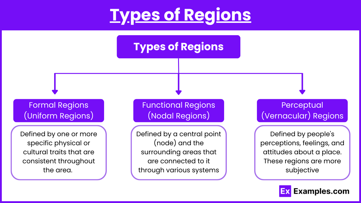
Formal Regions (Uniform Regions):
Defined by one or more specific physical or cultural traits that are consistent throughout the area. These traits can be measurable and quantifiable, such as language, climate, or governmental structures.
Examples include:
Countries (political boundaries).
Climate zones (like the Sahara Desert as a dry, arid region).
Crop-growing areas (such as the Corn Belt in the U.S.).
Functional Regions (Nodal Regions):
Defined by a central point (node) and the surrounding areas that are connected to it through various systems such as transportation, communication, or economic activities.
Functional regions are organized around a focal point, where activities or interactions diminish as one moves away from the node.
Examples include:
The metropolitan area of a city (like the New York metropolitan area).
The area served by a particular radio station.
A major airport and its associated transportation network.
Perceptual (Vernacular) Regions:
Defined by people's perceptions, feelings, and attitudes about a place. These regions are more subjective and vary depending on individual experiences and cultural backgrounds.
Perceptual regions are often based on how people perceive their surroundings, and they are not always as clearly defined as formal or functional regions.
Examples include:
The American "Midwest."
The "Bible Belt" in the southern United States.
The idea of the "Middle East" as a cultural region.
Key Concepts in Defining Regions
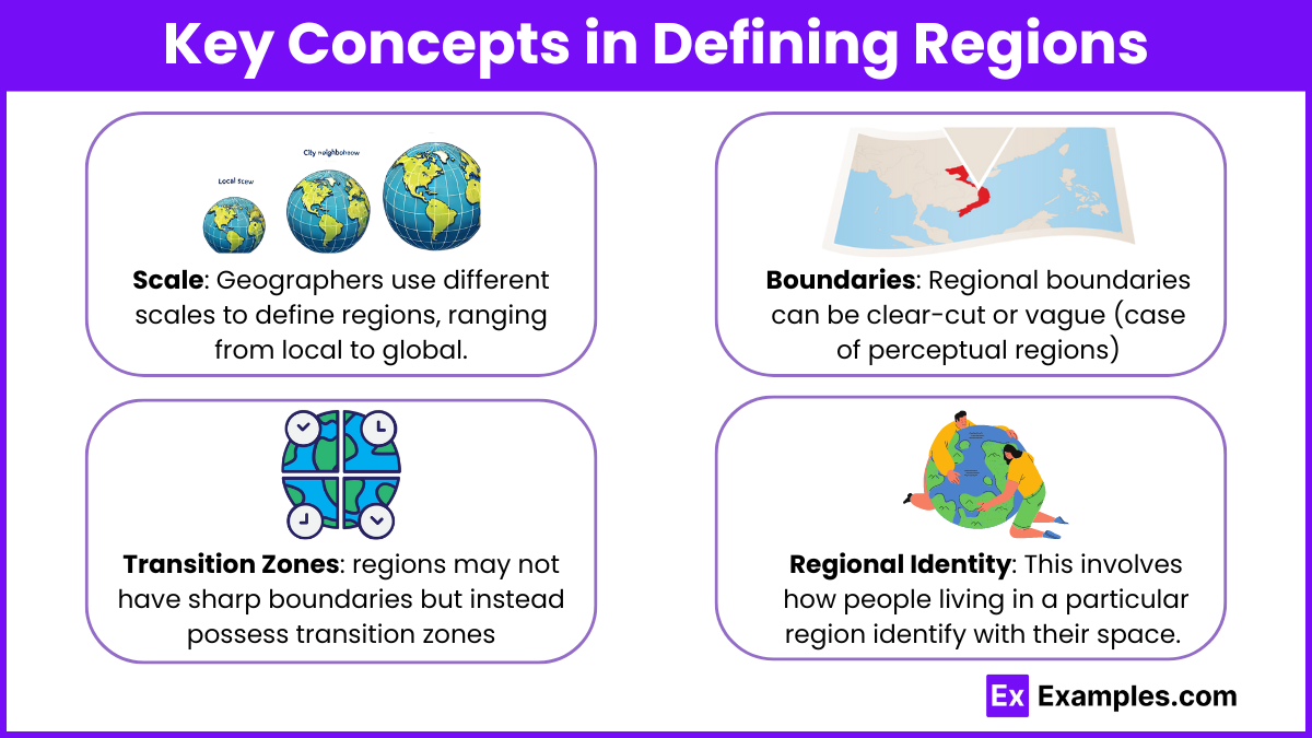
Scale: Geographers use different scales to define regions, ranging from local to global. A region might be as small as a neighborhood or as large as a continent.
Boundaries: Regional boundaries can be clear-cut (as in the case of formal political regions) or vague (as in the case of perceptual regions).
Transition Zones: In some cases, regions may not have sharp boundaries but instead possess transition zones where characteristics of one region gradually change into another.
Regional Identity: This involves how people living in a particular region identify with their space. For example, cultural identity may shape a person's view of the region they belong to, which can affect how the region is defined or understood by outsiders.
Importance of Regions in Geography
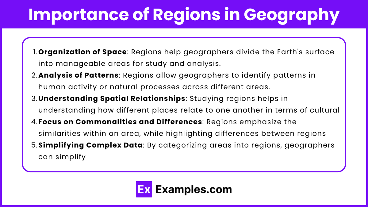
Regions are essential to geographers because they allow for the organization of space and help with the analysis of patterns, processes, and spatial relationships. By studying regions, geographers can make sense of the world by focusing on the commonalities and differences between different areas, whether related to human activity or natural processes.
Here is the importance of regions in geography:
Organization of Space: Regions help geographers divide the Earth's surface into manageable areas for study and analysis.
Analysis of Patterns: Regions allow geographers to identify patterns in human activity or natural processes across different areas.
Understanding Spatial Relationships: Studying regions helps in understanding how different places relate to one another in terms of cultural, economic, or physical connections.
Focus on Commonalities and Differences: Regions emphasize the similarities within an area, while highlighting differences between regions, aiding in comparative analysis.
Simplifying Complex Data: By categorizing areas into regions, geographers can simplify and generalize complex geographical data for better understanding.
Examples
Example 1: The Rust Belt (Perceptual Region)
The Rust Belt refers to a region in the northeastern and midwestern United States characterized by declining industry, aging factories, and a shrinking population. It is not formally defined by strict boundaries but is understood based on people's perceptions of economic decline and the shift away from manufacturing. This region illustrates how perceptual regions are shaped by cultural attitudes and shared experiences rather than by clear geographic borders.
Example 2: The European Union (Formal Region)
The European Union (EU) is a formal region defined by political and economic agreements between its member states. The EU has specific criteria for membership, including adherence to certain political, legal, and economic standards. The region is unified by common institutions and laws governing trade, travel, and political cooperation, making it an example of a formal region based on uniform political characteristics.
Example 3: The Amazon Rainforest (Formal Region)
The Amazon Rainforest is a formal region defined by its consistent ecological characteristics, such as tropical climate, dense vegetation, and high biodiversity. It spans across several South American countries, including Brazil, Peru, and Colombia, and is distinguished by its uniform climate and ecosystem. The boundaries of this region are defined by environmental factors, such as rainfall and vegetation patterns.
Example 4: Greater Tokyo Area (Functional Region)
The Greater Tokyo Area is a functional region centered around Tokyo, Japan's capital and largest city. It is a nodal region where economic, transportation, and social activities are highly concentrated in Tokyo, but influence spreads to surrounding areas through a complex network of railways, highways, and business connections. The region’s boundaries are determined by the reach of its infrastructure and economic interactions rather than political borders.
Example 5: The Middle East (Perceptual Region)
The Middle East is often defined as a perceptual region, shaped by cultural, historical, and geopolitical associations. The boundaries of the Middle East vary depending on the source, but it typically includes countries like Saudi Arabia, Iran, and Egypt. The region is unified by shared cultural traits such as religion (predominantly Islam), language (Arabic in many countries), and historical ties, though political and geographic boundaries can blur depending on the perspective. This example highlights the subjective nature of perceptual regions.
Multiple Choice Questions
Question 1
What is the primary difference between formal regions and perceptual regions?
A) Formal regions are defined by measurable characteristics, while perceptual regions are based on personal beliefs or feelings.
B) Formal regions are organized around a central node, while perceptual regions are based on measurable characteristics.
C) Formal regions change frequently, while perceptual regions have fixed boundaries.
D) Formal regions do not exist in the real world, while perceptual regions are the only regions recognized by geographers.
Correct Answer: A
Explanation: Formal regions are defined by specific, measurable characteristics, such as a common language, political system, or climate. For example, a formal region could be a country with defined political boundaries. On the other hand, perceptual regions (also known as vernacular regions) are based on people's perceptions and feelings about a place, which can vary from person to person. For example, the "Deep South" in the U.S. is a perceptual region that does not have precise boundaries but is recognized based on cultural and historical perceptions.
Question 2
Which of the following is an example of a functional (nodal) region?
A) The Sahara Desert
B) The area served by a local newspaper
C) The Corn Belt in the United States
D) The American Midwest
Correct Answer: B
Explanation: A functional (or nodal) region is organized around a central node, and its influence diminishes as you move away from that point. In this case, the area served by a local newspaper is a functional region because the newspaper serves a central area, and the influence of that service (the distribution of the newspaper) decreases further away from the central point (where the newspaper is produced). The other options represent either formal or perceptual regions. The Sahara Desert is a formal region, while the Corn Belt is also formal due to consistent agricultural production, and the Midwest is a perceptual region.
Question 3
Which of the following statements best describes the concept of transition zones in geography?
A) Transition zones are areas where two regions meet and share characteristics of both.
B) Transition zones are the central points of functional regions.
C) Transition zones are used to distinguish perceptual regions from formal regions.
D) Transition zones are sharp boundaries that separate different formal regions.
Correct Answer: A
Explanation: Transition zones are areas where the characteristics of one region gradually change into those of another region. These zones often exist between different formal regions, such as between a desert and a grassland. Rather than having clear-cut boundaries, these regions blend into each other, making the division less defined. For example, the area where the Great Plains meet the Rocky Mountains has characteristics of both regions, making it a transition zone. The other choices are incorrect because they misunderstand the nature of transition zones as gradual and fluid rather than fixed and sharp boundaries.